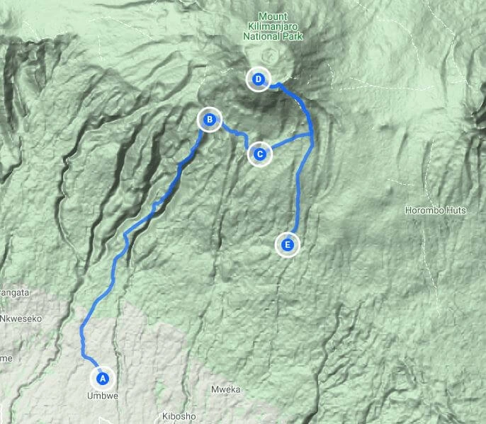
Umbwe Route Kilimanjaro
Most difficult approach to Uhuru

Most difficult approach to Uhuru
Umbwe route up Kilimanjaro is the steepest and least used trail on Kilimanjaro. It is a quiet route as a result but has a very
rapid ascent making it suited only to experienced climbers. The route
through the forest is also steep and
along the route are sections up steep narrow ridges.
As with most other routes on Kilimanjaro, you sleep tents overnight
on Umbwe. Then the route heads directly to Barranco Camp where it meets up with Lemosho, Shira and Machame Routes.
It heads from Barranco
Camp up Barranco wall through the Karanga Valley before climbing towards Barafu Hut. A good idea is to
tag on a further day at Karanga Camp to acclimatise better.
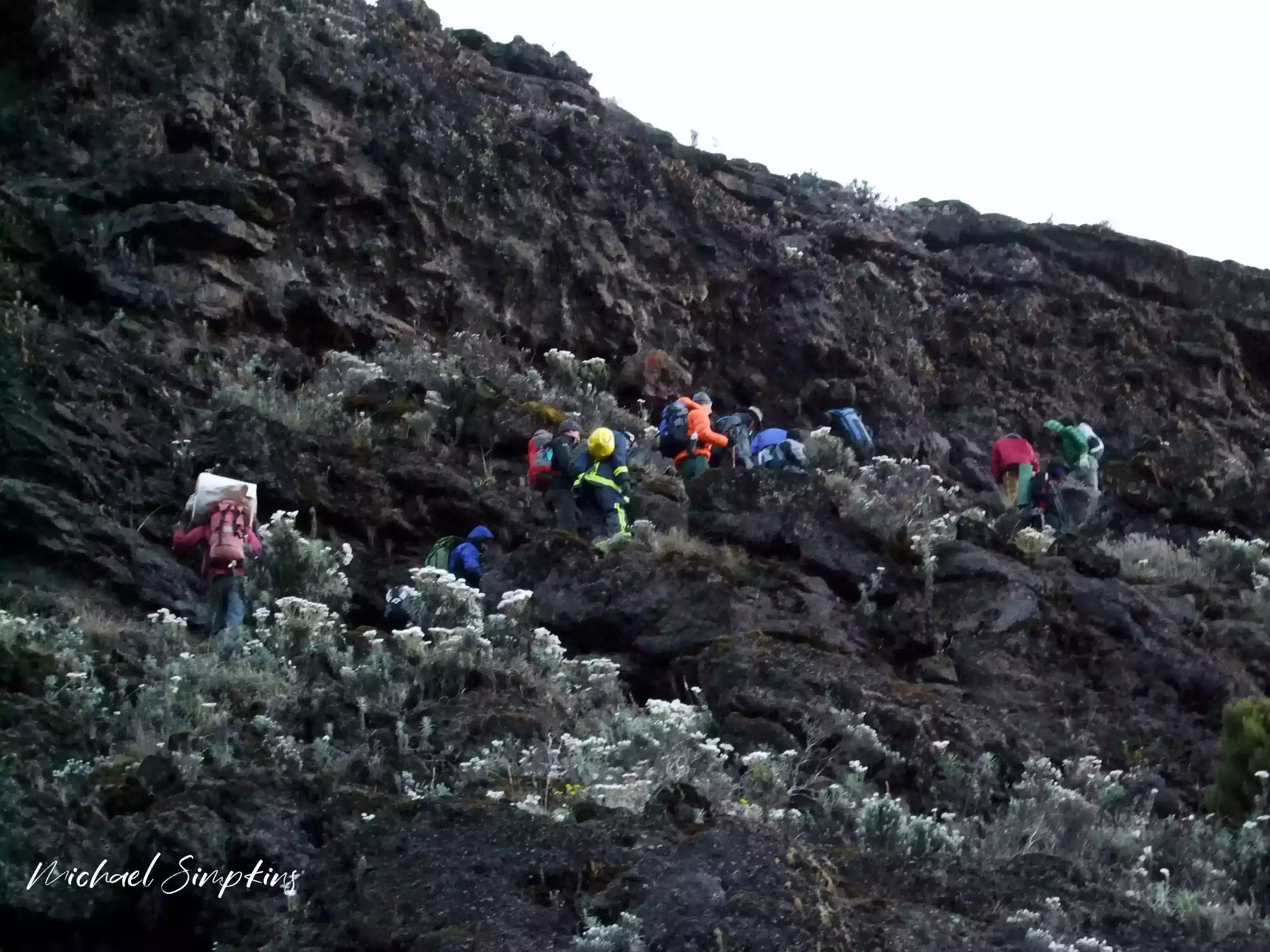
While Umbwe route is a non-technical climb, it does
offer steep ascents and requires trekkers to scramble over rocks and
tree roots at certain points.
Descent is made via the Mweka route
Being equatorial, Tanzania has two wet
seasons.
The first is the long rains from March to May, and then a short rainy season in
November. The daytime temperatures tend to range
around 32 to 38 degrees C in the forest, to anything from -2 to 6
degrees at the summit. Nights tend to range from 10 degrees down to well
below freezing. Summit temperatures can drop below -20C.
Distances trekked per day vary,
between 6km’s on day two, to close on 30km’s on the day of your summit,
dependent on which route you take.
The warmest months with the clearest trekking days on Kilimanjaro, are from mid to late December, January, February, September and
October. The rains often come in April and the start of May with the
possibility of some snow. June through to August are superb trekking
months, though evening temperatures tend to be colder. The wettest
months on Kilimanjaro are
November and early December, where snowfalls are likely. Note, that as
this is a mountain it is not impossible to get sporadic snow or rainfall
at odd times throughout the year, although the snow normally only falls
above 4800m.
As part of your Kilimanjaro Park Fee, emergency evacuation services
are included. This means that you will be carried down to the base of
the mountain as quickly as possible, on a mountain stretcher. In many
cases, a foot evacuation is quicker than waiting for insurance cover to
arrange the logistics for a helicopter.
There
are helicopter evacuation points on all of the major routes at specific
locations, namely Horombo, Barranco, Barafu, Kosovo, Stella, Millennium
and Shira. All points are within less than five hours from the crater
by stretcher and SAR emergency medical service can be deployed within 5
minutes from Kilimanjaro or Meru, regardless of the season.
Of course, nothing is free and deployment of this service is
contingent on you already have an insurance covers for evacuations to
6,000 meters above sea level.
So lets start with the worst problem of all; human waste. It
is something we all need to do at some point of the day and there are purpose
built toilets at each camp and at some places along the route. If you are on Marangu
you fill find nice flush toilets but for the rest of the mountain they are long
drops. Lower down the mountain in the forest zone and at the first camps, the
toilets smell due to low altitude and warm weather during the day. The effect
of this is that many people elect to go outside the toilet in the surrounding
area, resulting in unwanted piles of human waste and toilet paper littering the
area. The situation at Crater camp at 5700m is even more dire, where they are
no custom toilets meaning that the only places to go are in and around crater
camp itself. Due to the sub zero temperatures, nothing freezes. Between camps,
there are few, if any toilet facilities.
For the reasons mentioned above, regardless of how dire the
conditions are in the toilet we ask that climbers make use of them. They are there for good reason. Take vicks and
rub it under your nose if you must. If
not, hire a toilet tent where the waste can be properly disposed of. And if you
really do need to go between camps, find yourself a “loo with a view” a good
20m off the trail and away from any streams, dig and hole and bury your
deposit.
Everything that is carried up the mountain that is not consumed must be brought back down again. At every camp, the gear that the porters carry must be weighed on leaving each camp and again on arriving to the next one. KINAPA enforces strict regulations to keep Kilimanjaro clean. Licenses are easily revoked or heavy fines imposed if it is found that a guide is leaving litter on the mountain. So in theory, all you have to do is give your little paper bag to the kitchen team to be carried off the mountain or better still, leave it in a bag in your duffel and dispose of it when home. Why paper bag? Simple, plastic is a global curse and as of 1 June, Tanzania has banned the use of plastic bags. Anyone arriving into Tanzania will have to “surrender” plastic bags in their possession before entering the country. En route to summit, sucking on glucose sweet helps with thirst and a dry mouth but sadly, most of those sweet wrappers find there way to the scree paths. If you have the energy to dig out a sweet and open it, then you have the energy to put the wrapper back in your pocket. The same applies to hand warmers and dead camera batteries.
The cost of a medical evacuation from the mountain is expensive, which is why adequate travel insurance is required on all climbs booked through us. Adequate, means you must be covered for
1) Trekking or hiking – this may sound strange, but many insurance list that as an exclusion.
2) Altitude up to 6,000 meters. Most travel insurance providers do
not include this under their standard cover and often limit it to 3500m
or less.
3) Sprains strains and physiotherapy – yes, many insurers exclude
this; though ironically, this is what you will most likely need cover
for.
4) Personal accident – this is the horrible part of insurance. Yes,
you need to be covered in the case of death. We are often told by
clients – “if anything happens to me, just leave me there.” It is not
that simple.
Day-1: Arrive Kilimanjaro International Airport and transfer to hotel. Overnight hotel.
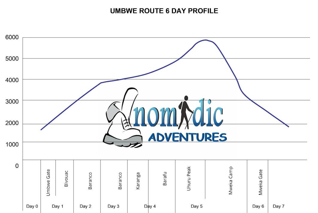
 Day-2:Umbwe Gate (1800m) - Bivouac (first) camp (2940m)
Elevation: 1800 metres to 2940 metres
Distance: 8 kilometres
Trek time: 5 hours
Environment: Montane Forest
After breakfast you will be driven to the Umbwe Gate at 1800m, passing through villages with banana and coffee plantations. On arrival at the Parks Gate your guide and porters will meet you. You will have to sign the register before you enter the park. As you head into the forest, temperature scan rise to about 35 degrees C, but as you quickly rise in altitude, they will progressively drop, by about 1 degree for each 200m climbed. The paths can also be quite muddy. The route initially follows a forestry track winding up through the natural rain forest. It then narrows and becomes steeper as you climb the ridge between the Lonzo and Umbwe rivers, with huge trees surrounding you. The path offers some spectacular views of deep gorges and if you are lucky, glimpses of Kilimanjaro towering above you in the distance. The camp is perched between huge trees and thick undergrowth.
Day-3: Bivouac (first) camp (2940m) - Barranco (3950m)
Elevation: 2940 metres to 3950 metres
Distance: 6 kilometres
Trek time: 6 hours
Environment: Heath land
Shortly after leaving the camp the forest starts thinning and is replaced by rockier terrain, sparser undergrowth and straggly, moss-covered trees. The path continues along a narrow, but spectacular ridge and as it ascends through the heath, the ridge narrows and sharpens quite quickly. As you gain higher altitude, you will note how quickly the various vegetation zones change. Sighting of Lammergeyer are quite common. The path flattens as you approach Barranco Valley . From the Umbwe ridge the route descends slightly to the Barranco camp. The camp is situated in the valley below the Breach and Great Barranco Wall, which should provide you with a memorable sunset.
Day-4: Acclimatization Day
This day will be spent at Barranco camp to aid with acclimatization. You can spend the day walking around to explore the surrounding areas such as up to the Barranco wall, take in sights of the magnificent Scenecio's, or just rest.
Day-5: Barranco (3950m) to Barafu (4550m)
Elevation: 3950metres up to 4550 metres
Distance: 13 kilometres
Trek time: About 7 hours
After breakfast you will begin the scramble up the Great Baranco Wall and then begin the traverse over the scree towards the Karanga Valley at 4000m. It is here that you will get the incredible views of the Heim, Kersten and Decken glaciers. After leaving the Karanga Valley , you will continue along the trail to Barafu Hut. You will now find yourself completely in the alpine desert of crushed stone and scree. The campsite is very cold and gets buffeted by the wind. Barafu is the Swahili word for "ice". The summit is a further 1345m up. It is this ascent that you will tackle in the early hours of the next morning. That night, it is important to prepare your gear, lay out your clothing etc for your summit attempt. It is also highly advisable to sleep with your water bottles to prevent them from freezing up overnight. Ensure that your headlamp had a new battery and that you have spare camera batteries if necessary. You will head for bed around 18h30.
Day-6: Barafu camp (4550m) - Uhuru Peak (5895m) - Mweka (3100m)
Elevation: 4600 metres to 3100 metres
Highest point: 5895 metres (Uhuru Peak)
Distance: 30 kilometres (7 kilometres ascent, 13 kilometres descent)
Trek duration: 13 to 16 hours (6 - 8 hours ascent, 7 - 8 hours descent)
Environment: Stone scree / ice-capped summit
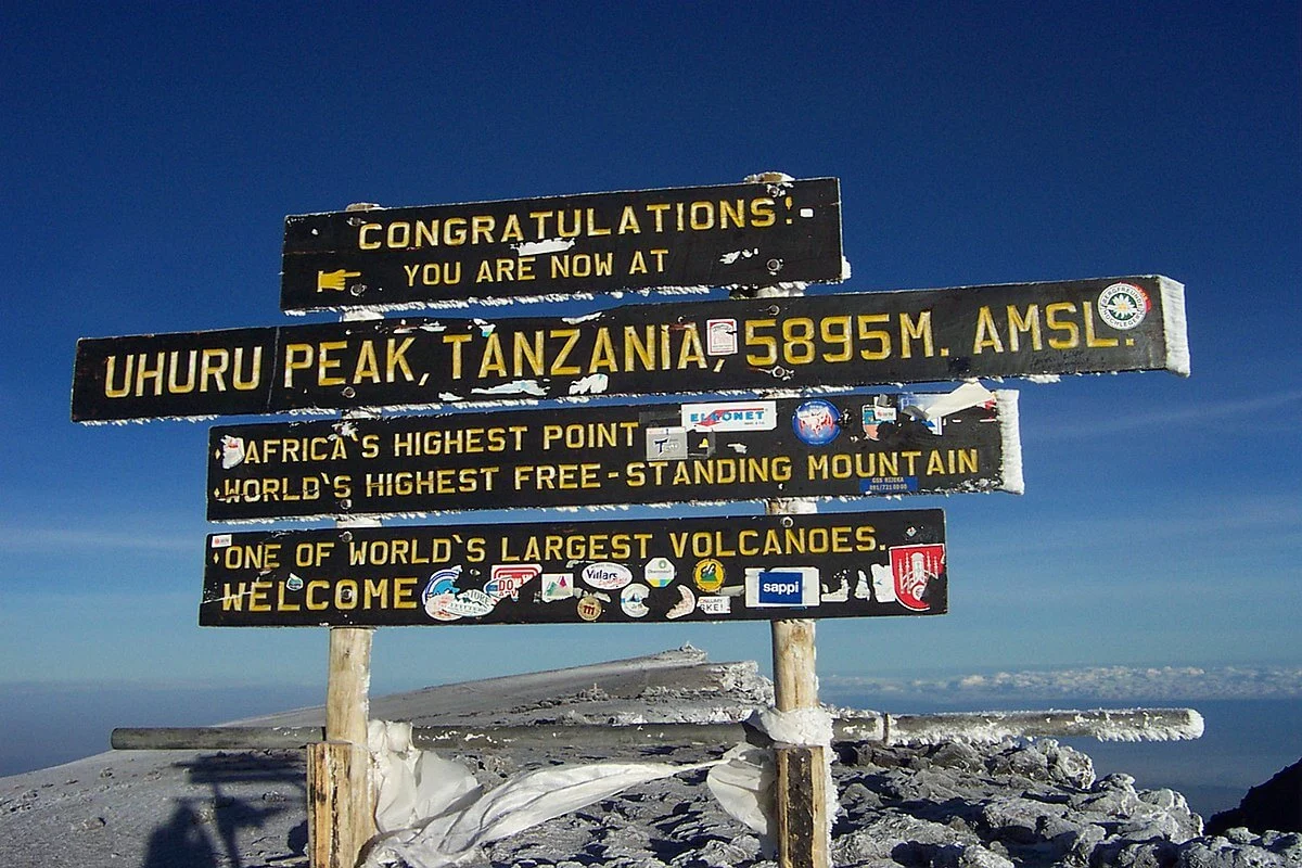
You will wake around 23h00 and after a cup of tea and a biscuit, shuffle off into the night for the summit of Kilimanjaro. The route heads up between the Rebmann and Ratzel Glaciers towards Stella Point and then on to Kilimanjaro Uhuru Peak where you will enjoy the magnificent views and a well deserve photo opportunity.
You will then descend back down to Barafu camp from the summit, which takes about 3 hours. The route is not difficult and will take you down the rock and scree path into the moorland and eventually into the forest. Mweka camp is situated in the upper forest and mist or rain can be expected in the late afternoon. Dinner, and washing water will be provided as well as drinking water.
Day-7: Mweka camp (3100m)- Mweka Gate (1980m)
After an early breakfast, it is a short 3-hour scenic hike back through a beautiful forest to the Mweka gate. At Mweka gate you will have to sign your name and details in a register in order to receive you summit certificates. Those climbers who reached Stella Point (5685m) are issued with green certificates and those who reached Uhuru Peak (5895m) receive gold certificates. From the Mweka Gate you will continue down into the Mweka village, normally a muddy 3 km (1 hour) hike. In the Mweka village you will meet up with your team and bus, and head back to the hotel a long over due hot shower.
Day-8: Depart
After breakfast, transfer to Kilimanjaro airport for your departure flight home.
End of services
No. Kilimanjaro is a trekking peak in that you essentially hike or trek to summit. No technical expertise is required, nor use of rope etc. There are sections on the mountain which require a scramble up rocky areas, dependant on which trekking path you follow.
Umbwe is done over as little as 6 days. However it is best done over 7 days to add on one acclimatisation day and increase your chances of success.
Umbwe Route is approximately 75 km /46.6 miles from gate to gate
Umbwe route - as with most other routes, accommodation is in tents.
There are several streams on the trail and porters will collect water from them. The cook then boils this water for you to fill you water bottles for your days hike. You can also use purifier tablets in stream water or add it to your boiled water however it can also have an effect on the diamox and make you feel nauseous. The higher you climb the less water there is. On the Machame trail, for example, the last water point is at the Karanga Valley, the lunch-stop before Barafu; on Marangu, it’s just before the Saddle. For this reason it is essential that you carry enough bottles for at least two litres.
June to October. Kilimanjaro is equatorial which means minimal variation between the seasons. However, there are two rainy seasons in Tanzania, the first is from March to May (short rains) and November to December (longer rains) which can make the forest track very muddy and of course, snow and/or rain higher up.
Although Kilimanjaro is classified as a ' trek,' it has a very fast altitude gain. Climbing Mount Kilimanjaro requires physical fitness training and stamina and most importantly, mental fitness training. Your legs will get you up the first 4-5 days but for your summit night, mental strength will get you to the top - (assuming of course that you are not affected by altitude, sickness or pure fatigue). A good exercise and training program is essential. The climb should not be undertaken lightly, after all, why spend the money if you are not willing to prepare yourself physically as well?
This really depends on the operator you travel through. The parks Kilimanjaro Park authorities do not ask for any medical information on the climbers when permits are purchased. Some operators request the clients complete a medical form, others do not. We require that all of our clients complete a medical form and based on the answers, we may request a letter from your medical practitioner. People suffering with conditions such as severe asthma e.g. should not climb. Regardless, anyone attempting the climb, or any climb for that matter, should ensure that they are medically fit, and convey any medical conditions to the operator they book with.
This is one of the most often asked questions - "how will I cope with the altitude". To be honest, this is an ' unknown' factor as no-one can predict how your body will cope at altitude. People who have been to altitude many times in the past without problems, may on one climb suddenly develop problems. There are many factors that play a role. The only way to help combat this, is to take all of the necessary precautions, and walk slowly, pole pole. Choosing a path like Machame where you get to follow the principle of "climb high, sleep low" is also advisable.
There are certain essentials that are needed for most climbs and Kilimanjaro is no different. The best way to draw up your list is from the base up, i.e. thermal underwear, then hands and feet (gloves, socks etc). Then boots which must be waterproof with good ankle support, trekking pants, trekking tops, short and long sleeve, thermal jacket, outer shell jacket which likewise is windproof and water proof, hat, scarf, beanie, balaclava. Then consider sleeping, i.e. sleeping bag, mat etc. Most companies supply sleeping mats so check before you buy one. Then, the last items to add are personal items like toiletries, camera, medicines, water bottle, backpack, camera etc.
Most companies will supply you with a comprehensive list for your trek, as do we. If you arrive to Kilimanjaro and are missing items, you can normally rent most gear. Do not, however, reply on buying your gear on arrival.
Unfortunately this is something every trekker has to consider. Anything from a stomach bug to altitude sickness can quickly stop a trekker in their tracks. If you are ill and need to turn back or even too tired to continue, a porter will walk off the mountain with you and your gear. If you are too sick to walk, then part of your fee includes evacuation by teams already on the mountain and employed by the Parks authorities.
Yes you do. We (Nomadic Adventures) do not allow anyone to climb with us unless they have adequate travel insurance. Adequate, means you must be covered for
1) trekking or hiking - this may sound strange, but many insurance list that as an exclusion.
2) altitude up to 6,000 meters. Most travel insurance providers do not include this under their standard option and often limit it to 3500m or less.
3) Sprains strains and physiotherapy - yes, many insurers exclude this, though ironically, this is what you will most likely need cover for.
4) personal accident - this is the horrible part of insurance. Yes, you need to be covered in the case of death. We are often told by clients - "if anything happens to me, just leave me there." Bodies need to be brought home or laid to rest overseas, and this can run into thousands of dollars, creating a huge burden on family members.
We will assist in helping you provide good cover. If you need cover or simply a quote, follow the details herewith:. Once you have done your initial quote, you will need to upgrade your cover to include altitudes up to 6000m. Towards the bottom of the page you will see a section called, Options: Upgrade your cover. Click the link called 'View Adventure Sports Benefits'. A blue pop up screen will open. Look for the level of cover required for 'trekking to 6,000 meters' or 'hiking to 6,000 meters'. Depending on your country it is usually a level 1 or 2. Note: we are not insurance experts and it's your responsibility to ensure you have correct and adequate cover. If you live in South Africa, we have other cover options
There are 7 summit routes; namely, Marangu, Rongai, Lemosho, Shira, Umbwe and Machame. Of all, Machame is by far the most scenic albeit steeper path up the mountain. The Rongai is the easiest camping route and the Marangu is also easier but accommodation is in huts. As a result, it tends to be very busy and ascent and descent are the same. Both of the latter have lower prospects to acclimatise by the climb high sleep low principle unless one adds on extra days. The Northern Circuit, approaches Kibo volcano from the west, crossing the caldera of Shira Volcano before turning north to follow the trail through Moir Valley and around the northern side of Kilimanjaro. For a quick overview we have a quick reference panel on the right of the screen. For a detailed look, click onto Kilimanjaro Trekking Routes.
The Kilimanjaro National Park fees are something that nobody can escape and are a large portion of your climb cost.. For a six day/five night camping trek you pay about $800 in fees alone! So on average a climb will cost you between $1450 and $2800 depending on the number of days, number of people and the route that you take. There are some operators who will quote you $1000 for a trek - ask yourself, what are they skimping on and who is going to suffer as a result. You? Your safety? The porters?
There are so many good books written on Kilimanjaro. Some of the ones we suggest are:-
1) Kilimanjaro: The Trekking Guide to Africa' s Highest Mountain by Henry Stedman
2) The Snows of Kilimanjaro by Ernest Hemingway is a short story about a writer who is on safari in Tanzania
3) Kilimanjaro: To the Roof of Africa by Audrey Salkeld.
A link to Mount Kilimanjaro National Park website
Kilimanjaro National Park -UNESCO World Heritage Centre
Acute mountain sickness: MedlinePlus Medical Encyclopedia
Those who have climbed Mount Kilimanjaro know that the porters are the heart and soul of your trek. Without their hard work and strength we would not be able to fully experience the magnificence of Kilimanjaro. A link to the Kilimanjaro Porters Assistance Project
We arrange treks from just 1 person on their own with a guide and porters to large groups. If you climb alone you will still get to meet other people on the mountain if you are sociable.
Moon phases (Full Moon) 2022
|
Full moon |
January 17, 2022 |
|
Full moon |
February 16, 2022 |
|
Full moon |
March 18, 2022 |
|
Full moon |
April 16, 2022 |
|
Full moon |
May 15, 2022 |
|
Full moon |
June 14, 2022 |
|
Full moon |
July 13, 2022 |
|
Full moon |
August 11, 2022 |
|
Full moon |
September 10, 2022 |
|
Full moon |
October 9, 2022 |
|
Full moon |
November 8, 2022 |
|
Full moon |
December 7, 2022 |
Moon phases (Full Moon) 2023
|
Full moon |
January 6, 2023 |
|
Full moon |
February 5, 2023 |
|
Full moon |
March 7, 2023 |
|
Full moon |
April 5, 2023 |
|
Full moon |
May 5, 2023 |
|
Full moon |
June 3, 2023 |
|
Full moon |
July 3, 2023 |
|
Full moon |
August 1, 2023 |
|
Full moon |
August 30, 2023 |
|
Full moon |
September 29, 2023 |
|
Full moon |
October 28, 2023 |
|
Full moon |
November 27, 2023 |
|
Full moon |
December 26, 2023 |